
Mile Markers, Project Stationing & Offset Measurements
| ITSFM Home | New Users & Agencies | Standards | New Construction | Operations & Maintenance | Training |
| Contractor & Consultants | Construction, Engineering & Inspections |
| Roles & Responsibilities | Quality Assurance & Quality Control | As-Built Guidelines | As-Built Document Acceptance Testing |
| As-Built Plan Documents | ITSFM Documents | Documenting Change |
| Field Markups & Master Record | Mile Markers, Project Stationing & Offset Measurements |
 There are three types of measurements used to identify locations in the design, as-built plans and the ITSFM:
- Nearest Mile Marker
- Project Station
- Offset from travel lane
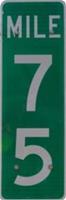
 Mile Marker measurements assign feature locations to the nearest 1/10th mile section along the roadway. All Site Identification Names (SIN) require reference to the nearest mile marker. SINs are required on both as-built plans and
ITSFM documents to provide an association between the as-built documents.
Mile Marker measurements assign feature locations to the nearest 1/10th mile section along the roadway. All Site Identification Names (SIN) require reference to the nearest mile marker. SINs are required on both as-built plans and
ITSFM documents to provide an association between the as-built documents.
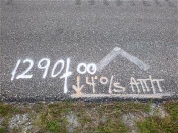
Project Station measurements are linear measurements tied to a baseline, typically the roadway centerline, and start and end at the project limits. Project stations provide a unique linear measurement number assigned to features
along the project that can be subtracted from each other to provide the distance between the features. Stationed features may include roadway items, such as culverts, drop inlets, bridge head walls, and mileposts. Stationed ITS features should include
transition points where the conduit system running line changes direction, conduit access points (splice vaults and pull boxes), ITS field device sites and electrical service points.
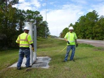
Offset Measurements denote how far away the feature is from a particular baseline structure, such as the centerline of roadway, edge of travel lane, or right-of-way fence. Offset measurements
should be shown at all ITS field device sites, electrical service points, along the conduit including points at the beginning and end of the conduit run, and at all points where the running line changes direction. The ITSFM only supports distance
to edge-of-travel-lane.